
The Challenge
Agricultural Paying Agencies and regulatory bodies across the UK and EU manage vast numbers of landowners yet struggle to maintain accurate, up-to-date insight into their land assets. They need automated, reliable satellite-based analytics to validate subsidy claims, track compliance, and monitor environmental interventions at scale – tasks that are increasingly difficult with traditional, labour-intensive methods.
Beyond Paying Agencies, a wide range of stakeholders including environment ministries, developers, infrastructure owners and more, face a similar challenge: understanding the true condition of their land and the ecological impact of their activities. These users must assess habitat quality, biodiversity value, and how their land interacts with the surrounding landscape, but currently lack consistent, data-driven tools to do so effectively.
FANTOM – Transforming land monitoring with accurate, automated environmental intelligence
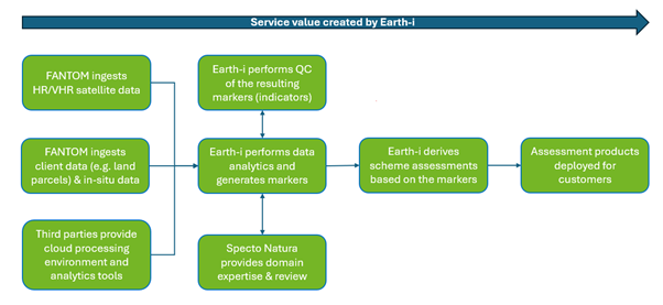
FANTOM (Future Analytics for Nature Through Observation and Modelling) is a project led by Earth-i with support from domain specialist Specto Natura. The project aims to transform environmental land monitoring across the UK and beyond. It is building a database of agricultural and biodiversity markers, creating novel environmental indicators directly from satellite imagery.
FANTOM turns satellite data into clear, actionable intelligence for landowners, regulators and agencies delivering reliable, landscape-level insights for smarter agricultural and environmental decisions.
Initially focussed on delivering markers to support schemes for agricultural Paying Agencies, the aim is to ensure that the markers and schemes have a wider commercial need across government, non-government and commercial markets.
The FANTOM platform is designed to provide content and context that supports not only agricultural schemes but also net zero and broader climate change mitigation activities.
The aim is to make a comprehensive database of markers and impact assessments available to all relevant governmental agencies, associated arms-length bodies and commercial companies, enabling them to monitor and measure the progress of their sustainability activities and interventions.
FANTOM’s ambition is to change the current approach to Earth observation-based land monitoring from not just looking at the asset, but also its relationship with neighbouring assets to support landscape-level sustainability activities across the wider landowning community.
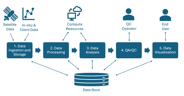
What FANTOM delivers
FANTOM delivers high spatial and temporal resolution markers to support agri-environmental schemes through the analysis of EO data and its integration with ancillary information.
The main subsystems and components of FANTOM are:
1. Data Ingestion and Storage: Handled primarily by Earth-i’s existing satellite & in-situ data processing workflow with necessary customisation for FANTOM.
2. Data Processing: Depending on the marker requirements:
- Processing scripts capture the workflow and procedures to be applied to the data to realise the markers and evaluations.
- An AI toolset provides the facility to analyse imagery using tools such as computer vision, machine learning and neural networks.
- Scheme scripts will combine information about multiple markers to perform scheme assessments.
3. Data Analysis: Analytics performed using a combination of sophisticated computer vision techniques and machine learning models to pick out specific identifiable features in the source satellite data. Outputs the markers required for the individual scheme assessments.
4. QA/QC Pipelines: QA/QC pipelines allow both manual and automated intervention.
5. Data Visualisation: Using existing platforms and open-source tools, visualisation will allow the user to overlay the resulting markers on the map, chart the outcomes and make rapid statistical assessments of marker outcomes and scheme results.
The Value of FANTOM
FANTOM will reduce the amount of time that it would otherwise take Paying Agencies to generate a full and comprehensive set of monitoring indicators for countries with agricultural monitoring requirements and a need to keep these aligned with evolving policies and regulations. This means they will be able to monitor compliance and effectiveness of new policies right from the outset.
The data products themselves represent value in the form of the customised, rigorously tested algorithms developed and implemented, along with a robust quality control regime, providing data that can be relied upon and can be verified with physical observations in the field. The markers and scheme assessment outputs scale reliably to address the Impact Potential, Technical Feasibility and Financial Viability of the monitoring.
FANTOM can promote the integration of ecological knowledge about the landscape into a data product and model the change of the Habitat Quality and Biodiversity Potential so that customers can consider how a scheme is influencing changes over time and integrate this into policy development.
The Future
The FANTOM project commenced in March 2025 and is ongoing with continued momentum.
The requirements baseline has been consolidated through workshops with key end users and stakeholders, exploring the technical, performance, timeliness, quality and product format requirements.
The project team is working to refine the product and performance specifications for selected high-priority, cross-cutting properties that underlie the development of the identified markers.
FANTOM’s deployment will enable a future where landowners, governments, and industry access clear, automated environmental intelligence. Helping them to improve compliance, guiding sustainable decisions, and delivering landscape-level insight to protect biodiversity, strengthen long-term land stewardship and support broader climate change mitigation activities.
The Consortium
Specto Natura is an earth observation consultancy that helps organisations to understand the world through observing nature’s connections.
Their projects provide insight in to how humans use the natural world, through the expert application of Earth Observation data. Organisations around the world rely upon their project planning, data collection, analysis, interpretation, reporting and training services.
Specto Natura’s experts understand the fundamental physical basis of the measurements being made, the processes they illuminate and the socio-economic and conservation impact.
The European Space Agency (ESA) is Europe’s gateway to space. Its mission is to shape the development of Europe’s space capability and ensure that investment in space continues to deliver benefits to the citizens of Europe and the world.