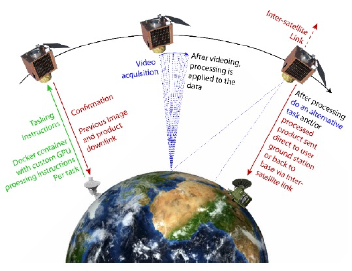
The Overpass concept
The concept behind the Overpass project was that optimising data processing on-board a satellite can substantially reduce the amount of data a satellite needs to store and downlink, increasing the satellite’s overall utility.
The project aim
To test this idea, the project developed, tested and demonstrated high-resolution optical video analysis techniques, involving both software and dedicated hardware such as Graphical Processing Units (GPUs).
Since it may not be possible to do all necessary processing on board a satellite, the project also trialed different approaches and determined the optimum combination of onboard and on-ground processing considering various hardware / software implementations and end user needs.
The project further researched how these capabilities could be deployed on-board British optical imaging satellites in future, with a roadmap for inclusion in a forthcoming constellation.
Specific processing capabilities explored:
- Super-resolution image enhancement;
- Sub-pixel 3D point cloud retrieval;
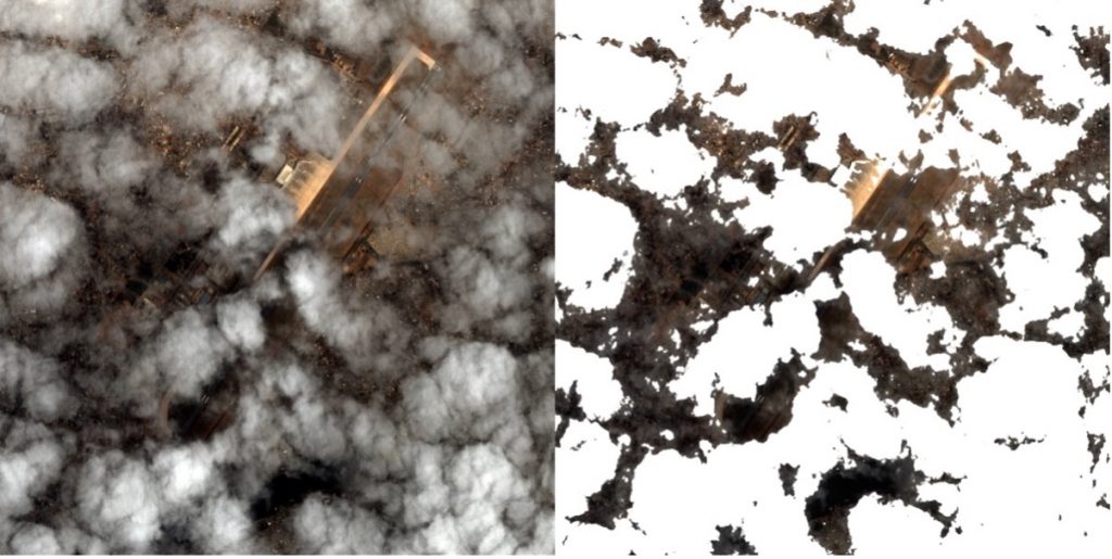
- Cloud detection and image quality assessment;
- Video compression;
- Change detection and moving object extraction.
Support from the Centre for Earth Observation Instrumentation (CEOI)
In order to develop the idea into a deployable technology, CEOI provided funding to a team led by Earth-i Ltd with UCL’s Mullard Space Science Laboratory and Cortexica Vision Systems as the project partners.
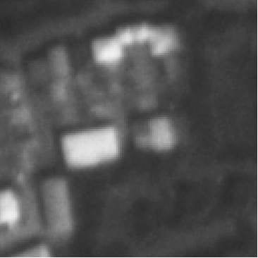
Overpass exploited techniques used to image the Beagle 2 lander on Mars and applied these Super Resolution Restoration (SRR) methods to Earth Observation imagery. The system sharpens (i.e. increases resolution of) imagery by combining images from multiple view angles.
Relation to previous CEOI projects
UCL have revisited and updated algorithms and approaches used to image Beagle and applied the resulting MAGiGAN SRR techniques to multi-pass EO imagery. Typically, an effective resolution enhancement of a factor of at least 3.75 times is obtained. This allows the creation of commercial imagery datasets with increased resolution, using multi-angle near simultaneous or repeat observations. This work will be further exploited within Overpass.
| 1.1m SSTL Carbonite-2 green band | Magigan SRR |
 |  |
The Results
The team identified several highly marketable opportunities resulting from incorporating such capabilities on-board the satellites of the future:
- Processing on-board the satellite can substantially reduce the amount of data to store and downlink, increasing the effective capacity and throughput;
- Compression offers reductions in data volumes, and works well with satellite video data where redundancy is high
- Cloud detection can be used to only downlink imagery if the target is visible
- Quality assessment on-board means unusable imagery need not be downlinked
- Extracting relevant information avoids downlinking entire video or image sets
- Processing the video data into data products can provide a product directly to the ground recipient that has already been processed prior to use, reducing the need for ground infrastructure for interpretation and reducing latency;
- In any case, where a visibility, quality or other assessment is made this can be fed back into the mission plan for automatic re-tasking with different specifications, such as to attempt acquisition from an alternative angle or with a different frame integration time.
Copyright 2018 Earth-i Ltd. Processing by Cortexica All Rights Reserved
The team also identified that this is a time critical opportunity to achieve deployment within commercially meaningful timescales as international competition is growing. It uses existing low-cost technologies for rapid deployment.
Wider Deployment
Optimising the processing and analysis of high-resolution optical images and video has significant potential application in a wide range of other sectors, including:
- Commercial security and surveillance
- Military situational awareness
- National security and resilience
- Bio-sciences
- Industrial processes
The Future
The team engaged with potential end-users of the resulting products and services and all have expressed a keen interest in exploiting such technology in future.
The technology is now being considered in the design reviews for several visible imaging instruments to go on potential future missions.
Its deployment in New Space satellite constellations will transform the ability of Earth Observation instruments to provide contemporaneous data and products, enabling a wide range of new and innovative downstream services for sectors ranging from agricultural and construction, through energy, insurance and water to governmental requirements for policy, planning, and land use.
CEOI
The Centre for Earth Observation Instrumentation (CEOI) works with UK organisations, both academic and industry. Its objective is to develop a world leading, internationally competitive, national Earth Observation (EO) instrument and technology R&D capability, enhanced through the teaming of scientists and industrialists. The CEOI is funded by the UK Space Agency with parallel technology investment from industry. Further information about this technology and others funded by the CEOI can be found at ceoi.ac.uk.