Defence intelligence in an uncertain world
In an era of growing geopolitical instability, both the foundations of national sovereignty – security, stability, and prosperity – and the operating environment for commercial entities are under unprecedented pressure. Defence intelligence now plays a critical role as nations and businesses alike face multidimensional threats that span land, sea, and air and now increasingly, space.
Security of water, food, and energy is no longer solely a development concern but a matter of resilience and continuity. Economic security, internal cohesion, and border control are becoming strategic priorities for states, just as supply chain integrity, market access, and regulatory risk are becoming existential issues for industries. Modern defence intelligence capabilities must now address these civilian and commercial vulnerabilities as much as traditional military ones.
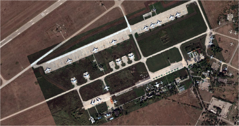
The global democratisation of space presents both opportunity and exposure, introducing new vulnerabilities for governments and enterprises. Both now require unrestricted, resilient access to Earth Observation (EO) data and independent, timely analysis to strengthen defence intelligence operations, and navigate evolving threats and shifting dynamics.
Space is emerging as the critical enabler: with access and reach, space can provide a strong deterrent to adversaries and a visible assurance to stakeholders. Yet without control over export regulations, or the capability to develop national expertise, many actors, both state and commercial, remain dependent on external providers, weakening their strategic autonomy at a time when sovereignty, insight, and independence matter most. Defence intelligence supported by sovereign space capabilities becomes a foundation of national resilience.
Delivering sovereign and commercial space capability and defence intelligence
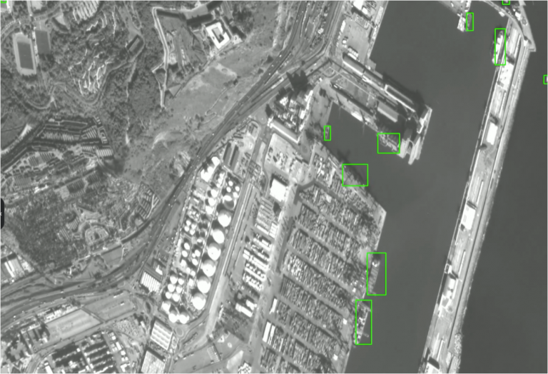
With over a decade of experience, Earth-i delivers a powerful, end-to-end capability that helps both nation states and commercial entities strengthen their strategic presence in space and transform their decision advantage. At pace, and de-risking traditional procurement routes, we provide access to a resilient, multi-operator and multi-sensor EO data supply chain, enabling broad area monitoring for governments and businesses alike to build enhanced domain awareness and understanding across internal, border, regional, and commercial environments. These insights directly enhance defence intelligence by integrating real-time Earth Observation into mission-critical decisions.
Our tailored EO and analyst training programmes, supporting by edge AI-powered learning management solutions, alongside capability-building in data processing, analysis, and dissemination, ensure critical knowledge is embedded within government departments, domestic institutions, and enterprise operations. This ensures that defence intelligence functions are not only informed but embedded and future-ready.
Earth-i’s defence, intelligence, and commercial consultancy is supplier agnostic, bridging policy, innovation, and industry to support national security programmes and corporate strategies with clarity, discretion, and neutrality. We also offer expert guidance on export control regulations, industrial cooperation / offset programmes and provide a consultative approach to enhance local and regional understanding, accessibility and alignment.
From strategy to execution, Earth-i empowers both sovereign and commercial actors to leverage space not just as a tool for observation, but as a strategic asset to build foresight and insight, a cornerstone of national resilience, operational awareness, and global competitiveness. At the heart of this is robust, responsive defence intelligence.
DSI challenge areas
These are the broader issues or needs that nations face, requiring space-enabled solutions and Earth-i support and expertise:
- Land, sea, and air security
- Water, food, and energy security
- Economic security
- Need for sovereign capability to support:
- internal security;
- border security; and,
- regional security.
- Global democratisation of space
- Need for unrestricted and resilient access to Earth Observation (EO) data
- Requirement for unbiased / independent industry and vendor market intelligence
- Need for space to act as:
- a deterrent for adversaries; and,
- assurance for citizens/population.
Earth-i service offering
These are some of the services and capabilities Earth-i provides to address the above challenges:
- Access to a multi-operator / multi-sensor resilient EO / satellite data supply chain to support increased domain awareness)
- Earth Observation (EO) and Intelligence Analyst training
- Knowledge and capability building in EO/satellite data processing, analysis, and dissemination
- Defence, security and intelligence consultancy
- Independent and unbiased consultancy across policy, industry, and innovation to support sovereign space capability and national security programmes.
- Local language delivery to support regional stakeholders and ensure understanding of EO data and insights