Military commanders and intelligence analysts can’t always position assets where they need them. Satellites can. And increasingly what they see isn’t just useful context, it shapes decisions about where threats are developing before they become crises.
The key is that satellites don’t need to catch a tank rolling down a road to reveal military build-up. The more reliable signals come from a wider set of data points read together over time: a vehicle park that suddenly fills up, fresh tracks cutting across open ground, a staging area that appears, grows, then clears.
Taken together, patterns like these show where forces are concentrating, how they’re moving and whether activity looks routine or preparatory.
It’s about patterns, not individual events
The discipline at the heart of military Earth observation is change detection; comparing imagery from the same location across multiple dates to find what has shifted. But change detection on its own only flags differences. The harder analytical task is understanding what those differences mean when read together.
A newly cleared area beside a road, a vehicle park cycling through unusual occupancy patterns — consistently fuller or emptier than its baseline, or moving through rapid fill-and-clear cycles — intensified track scarring on a bridge approach. None of these signals are conclusive by themselves. Read in sequence, across a site and over time, however, they start to describe behaviour. That’s the distinction between spotting an anomaly and understanding an operation.
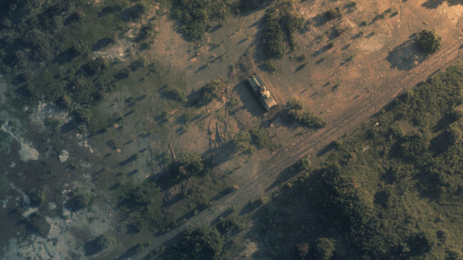
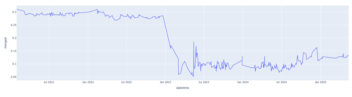
The frame sequence below indicates the visual occupancy level a military vehicle park over a time series. being full occupancy).
Without further analysis, the images themselves provide little intelligence. But with additional data and analysis, more information emerges – such as the chart below showing how the actual occupancy level has changed (with 1.0 being full occupancy).
Additional data and analytical processing makes the difference. Turning repeated imagery into usable intelligence means correlating signals across time, location and sensor type, and knowing which combinations of indicators carry real weight.
Change accumulates on the ground
Military activity leaves physical traces that persist long after the vehicles and personnel have moved on. Heavy equipment scars soil and flattens vegetation. Preparation work (scraped surfaces, levelled ground, temporary storage areas) exposes soil that reflects light differently from undisturbed terrain, making it visible even when the activity itself has moved on. Track patterns are often just as revealing: a fan of fresh parallel marks, repeated turn loops, or new links between a vehicle park and a road junction can indicate staging, manoeuvre rehearsal, or sustained convoy flow in ways that a single vehicle sighting never could.
Bridges and river crossings are particularly telling. Because they compress movement into fixed corridors, the ground around them records what has passed through. Approach roads showing heavy wear, hardstanding areas that fill and clear, queueing patterns on feeder roads. Bottlenecks like these become natural monitoring points precisely because activity can’t avoid them.
What makes all of this analytically useful is sequencing. Forces typically gather before large-scale movement in accessible open areas (industrial yards, roadside clearings, depots close to key routes) that were empty days before. A site fills. Roads begin to show repeated passage. Secondary areas activate. Then the original site clears. That sequence can describe preparation, pause and onward movement without ever requiring a perfectly timed image of the convoy itself.
Optical and radar imagery, used together
Optical imagery has limits. Cloud cover and darkness can interrupt collection at exactly the moments when monitoring matters most. Synthetic Aperture Radar (SAR) helps to address this. By using microwave signals rather than visible light, it captures imagery through cloud and at night, providing continuity when optical coverage breaks down.
The two sensor types also see the ground differently. SAR responds to surface roughness, moisture and structure in ways that optical sensors don’t, which means it can strengthen confidence in signs that optical imagery alone might leave ambiguous — disturbed ground, engineered positions, changing occupancy. Fusing the two data streams produces a more complete and reliable picture than either delivers on its own, and it’s this kind of multi-source analysis generated by companies like Earth-i that turns raw satellite data into something an analyst can act on.
From data to decisions
Earth observation reveals the footprint of military activity before movement begins, while it’s under way, and after it has passed through. But data alone doesn’t make decisions, analysis does.
That’s why Earth-i combines satellite collection and processing capability with direct military expertise. Working with clients to interpret what the data shows in operational context (not just what has changed, but what it likely means and what to watch next) is where the real value sits.
For organisations that need to understand developing situations quickly and with confidence, that combination of technical capability and analytical judgment is what makes satellite intelligence actionable.


