Satellite intelligence for ESG due diligence gives organisations independent, historical and current evidence to test investee claims against. It is strongest on environmental change and verifying physical assets, offers context rather than proof on social risk, and works best alongside physical audits and documentary checks.
The activity of companies and their suppliers is coming under increasing scrutiny as environmental, social and governance (ESG) commitments are tested against independently verifiable evidence. For organisations operating complex international supply chains, this creates a problem. How can they verify environmental performance, assess potential human rights risks and validate supplier claims when operations are spread across multiple countries, often in remote or difficult to access locations?
Satellite intelligence offers an independent source of evidence. By combining Earth Observation (EO) data with advanced change-over-time analytics, organisations can monitor levels of industrial activity, detect environmental change and identify discrepancies between reported information and observable conditions.
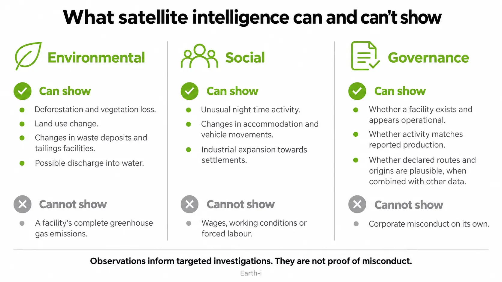
Its contribution to ESG due diligence can be an important part of the overall picture, although the type of intelligence required differs considerably between environmental, social and governance assessments. Satellite imagery is only one additional layer of data in the ESG monitoring toolbox and has its strengths and weaknesses. It is strongest in the environmental pillar, more indirect in social, and mostly corroborative in G.
Why is satellite intelligence becoming important for ESG due diligence?
Regulatory expectations around corporate sustainability have increased, particularly in Europe.
The EU’s Corporate Sustainability Reporting Directive (CSRD) establishes sustainability disclosure requirements for companies within its scope. Meanwhile, the Corporate Sustainability Due Diligence Directive (CSDDD) requires certain very large companies to identify and address adverse environmental and human rights impacts across their operations and relevant business relationships.
Both directives were amended in 2026, narrowing their scope and adjusting implementation timelines. Nevertheless, the need for reliable evidence remains. Investors, customers and regulators increasingly expect sustainability claims to withstand scrutiny.
Traditional due diligence relies heavily on supplier questionnaires, site visits, certifications and corporate disclosures. These remain essential, but may provide an understanding of the situation at a point in time and therefore an incomplete picture, particularly where suppliers operate in jurisdictions with limited transparency.
With the benefit of no privacy from space, satellite intelligence introduces a single geo-politically unbiased methodology to check those claims against independently observed activity, which helps manage ethical and financial risk. Put simply, satellite imagery is most valuable as independent, time-stamped evidence of physical conditions and change.
Fig I: What satellite intelligence can and can’t show
Environmental: monitoring the physical impact of industrial activity
Environmental performance is where satellite intelligence offers useful measurable contributions on how organisations manage their impact on the natural environment, including climate change, resource use, pollution, and biodiversity.
Satellite imagery can reveal how mining, manufacturing, agriculture and infrastructure operations affect surrounding land, vegetation and water systems. Historical imagery allows analysts to establish a baseline and measure how conditions change over months or years.
For companies assessing environmental risks across their supply chains, relevant indicators include:
- Deforestation and vegetation loss: Detecting forest clearance associated with mine expansion, agricultural development or new transport infrastructure.
- Water quality indicators: Identifying sediment plumes, changes in water colour and potentially concerning discharge patterns downstream of industrial facilities.
- Land use change: Measuring the expansion of extraction sites, waste storage areas and industrial infrastructure into surrounding habitats.
- Environmental management: Monitoring visible changes in tailings storage facilities, waste deposits and land rehabilitation.
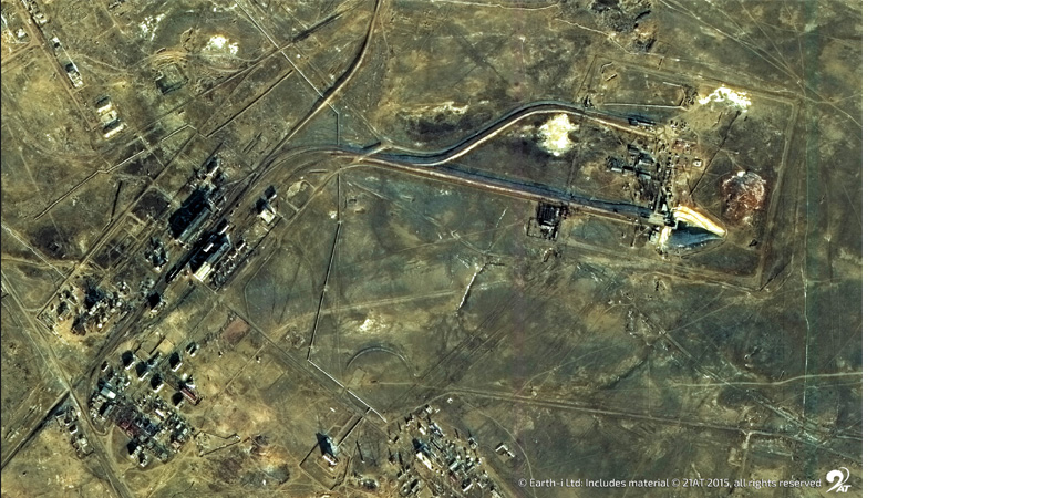
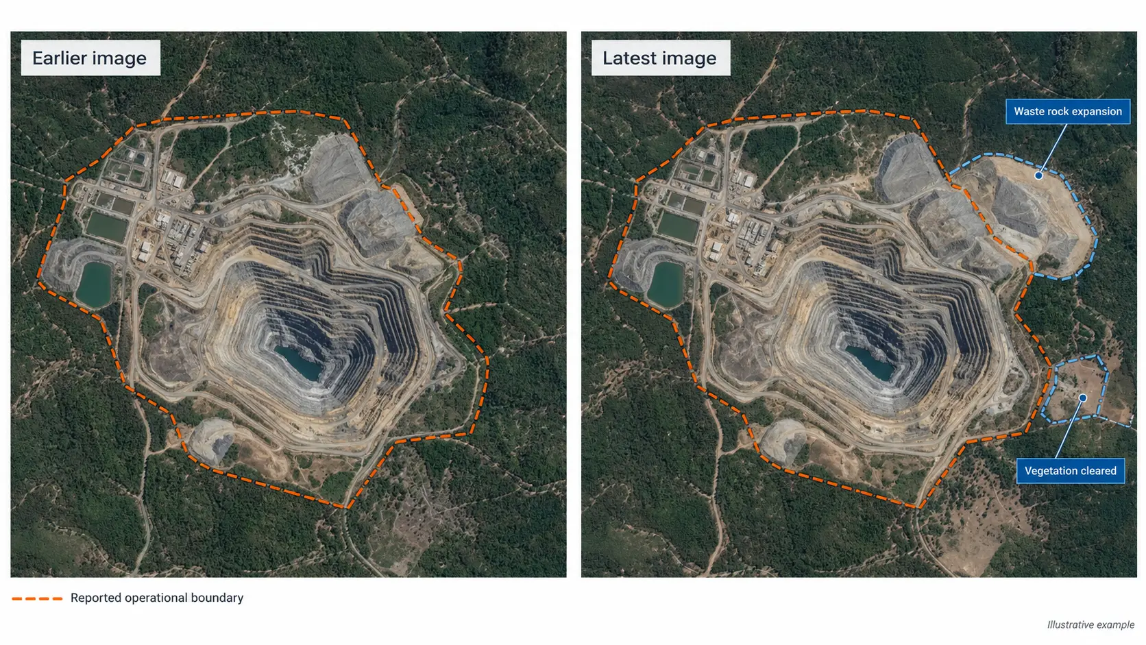
Consider a mining company reporting that its environmental footprint has remained stable. Satellite imagery may reveal continued expansion of waste rock deposits or vegetation clearance beyond the previously established operational boundary.
Fig II: Mine expansion beyond reported boundary
This evidence allows buyers, investors and compliance teams to question whether reported environmental performance reflects actual conditions and is complementary to, rather than a replacement of, environmental accounting or compliance testing.
Satellite intelligence also contributes to carbon accounting. Observed production activity, land clearance and infrastructure changes can help validate assumptions used in Scope 3 emissions estimates. However, satellite observations of operational activity cannot independently establish a facility’s complete greenhouse gas emission, which remain disclosure, meter, inventory, laboratory and audit questions under reporting regimes.
Social: identifying potential human rights and community risks
Social indicators present a different challenge.
Satellites cannot directly determine whether workers receive fair wages, experience unsafe working conditions or are subjected to forced labour. These issues require human investigation, documentary evidence and engagement with affected communities.
What satellite intelligence can provide is contextual evidence that helps organisations identify locations requiring closer examination.
For example, unusual nighttime activity at a remote mine or processing facility may indicate operating patterns that warrant further scrutiny. Changes in accommodation infrastructure in advance of formal audits, vehicle movement intensity and surrounding land use can provide additional context.
Satellite monitoring can also identify industrial expansion towards settlements, agricultural land or community water resources, which could raise questions about displacement, access to essential resources and local environmental impacts.
In mineral supply chains, this information is particularly useful where sourcing involves remote operations or areas associated with heightened human rights risks.
Unusual activity is not evidence of exploitation. A facility operating at night may be following entirely legitimate production schedules. These observations should therefore inform and help prioritise targeted investigations rather than be treated as proof of misconduct.
Governance: independently validating supplier claims
Governance concerns the integrity of corporate processes, including transparency, accountability and the reliability of information supplied to stakeholders.
Satellite intelligence supports governance assessments by providing independent verification of physical assets and operational claims.
For example, a supplier may claim that a particular mine or refinery is producing material at a specified rate. Satellite imagery can help establish whether the facility exists, whether it appears operational and whether observed activity is consistent with reported production.
The same approach can support responsible sourcing and supply chain traceability as well as validated industry and market news.
By combining satellite observations with shipping records, transport information, company reports and press releases, and other geospatial intelligence, analysts can assess whether declared material origins and logistics routes are plausible.
This becomes particularly valuable when organisations are investigating potential misrepresentation, unauthorised production or inconsistencies between supplier documentation and observable activity.
Such evidence cannot establish corporate misconduct on its own. It can, however, reveal discrepancies that conventional paperwork checks might miss.
Turning satellite observations into actionable due diligence intelligence
The greatest value comes from monitoring changes over time.
A single satellite image offers only a snapshot of that point in time. Repeated observations establish patterns, allowing analysts to distinguish routine activity from potentially concerning developments.
Combining optical imagery, radar, thermal observations and other data sources can provide a more complete understanding of industrial operations. Automated change detection and machine learning also make it possible to monitor extensive networks of suppliers with a single methodology and no geo-political bias, consistently.
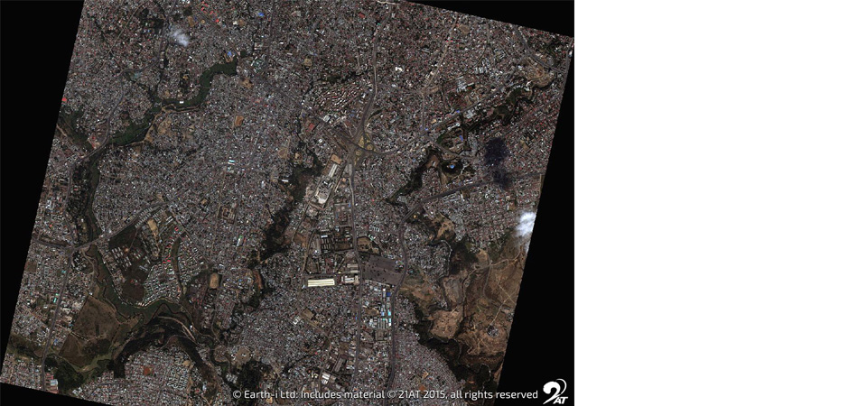
Fig III: Near-real time monitoring of change over of time of Industrial Activity and Production levels
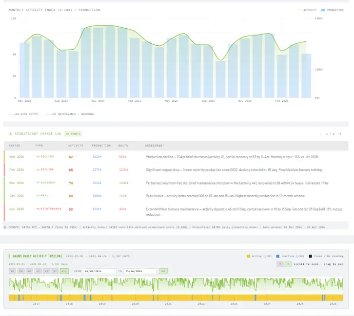
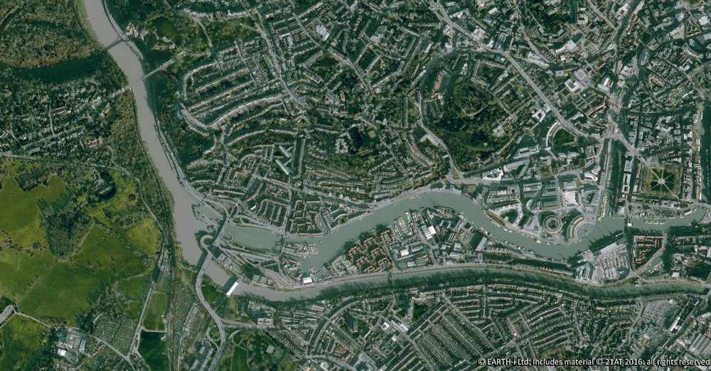
Fig IV: Near-real time monitoring of change over of time of Agricultural Activity and Compliance
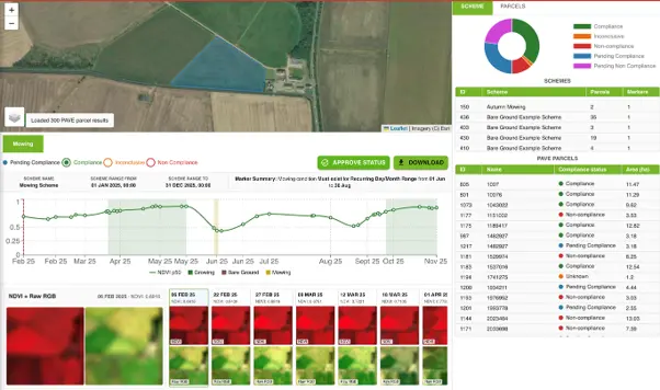
This enables organisations to receive near-real time alerts and warnings to help monitor and quantify risk, prioritise investigations, direct site audits towards higher risk facilities and maintain a documented record of observed changes.
At Earth-i, we combine multiple satellite data sources with geospatial analytics to provide satellite intelligence for ESG due diligence, assessing industrial activity and supply chain conditions. Our work across critical material supply chains helps organisations validate supplier claims, understand operational behaviour and identify emerging risks.
Satellite intelligence cannot replace regulatory compliance processes or on-site verification. Its strength lies in making those processes more informed, targeted and evidence based.
For businesses seeking greater confidence in their ESG reporting and supplier due diligence, satellite data is an opportunity to independently verify what is happening on the ground, identify concerns earlier and make decisions based on observable evidence rather than declarations alone.