
The Opportunity
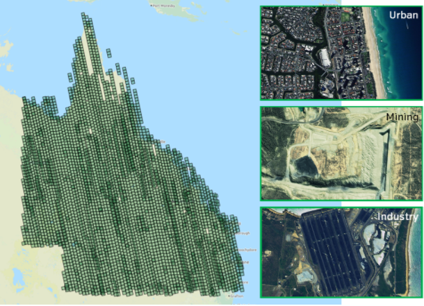
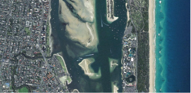
In 2016 the State Government of Queensland (Department of Natural Resources and Mines) committed to acquire very high-resolution satellite imagery of the entire state on an annual basis. Earth-i was able to demonstrate to the DNRM that full State-wide coverage was now possible at less than 1m resolution.
The 80cm pixel size data offered by Earth-i now enables new capabilities in a wide range of applications across all government departments whilst still meeting the requirement to collect 1.9million km2 of data in a three month period.
Such capability offers new benefits and advantages for the Queensland government in mapping this large territory and managing its diverse environment and natural resources.
The Task
On 15th December 2016 Earth-i was awarded the contract to supply the government of the state of Queensland, Australia with very high-resolution optical imagery of the entire state. The contract covers the supply of imagery from the DMC3 / TripleSat Constellation for each of the years 2016 and 2017 and will ensure that Queensland’s Department of Natural Resources and Mines
(DNRM) has a detailed imagery database of the entire state, updated each year.
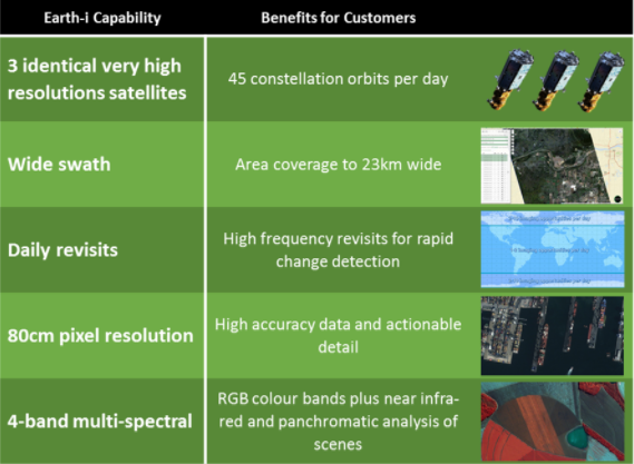
The DMC3 / TripleSat constellation is ideally suited to this task because it offers the optimal mix of capabilities for wide area acquisition, very high resolution and high quality of imagery.
The Service
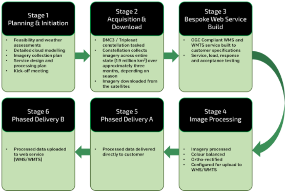
Earth-i is responsible for delivering an end-to-end service, covering six stages of program delivery from overall acquisition planning to processed image delivery to its customer at the DNRM:
Earth-i is one of the very first satellite Earth Observation companies whose Quality Management System and internal processes have been certified to the latest ISO9001:2015 international standard, providing assurance to customers of Earth-i’s quality processes for the efficient and timely delivery of satellite imagery and related data. The ISO9001:2015 certification ensures that Earth-i’s service delivery works within a framework of rigorous standards, focused on customer satisfaction and continuous improvement.
The Benefits
All Queensland Government Departments, local agencies and Natural Resource Management Groups will benefit from having access to up-to-date imagery of the State to support their decision making, information analysis, environmental management and state development activities.
Steve Jacoby, Executive Director of Land and Spatial Information, DNRM, said: “We are delighted to have awarded the contract to Earth-i. They demonstrated a clear understanding of our needs in Queensland, the DMC3/TripleSat Constellation provides us and other Queensland government departments with both the wide area capability and the very high-resolution imagery required to meet the needs of the user community. We were impressed with the professionalism of the Earth-i bid and the quality of data we will be able to work with to support a wide range of applications.”
Given the favourable economics of smaller, low-cost satellites such as DMC3, Earth-i has also been able to deliver such high-quality results at a very favourable price compared to traditional high-cost suppliers, representing excellent value for money for the Queensland Government.
For more information please contact: Paul Majmader, Director
Paul.majmader@earthi.space.co.uk or call +44 1483 668 237


