
For decades, innovation in defence intelligence has focused on helping commanders make better decisions. Better sensors, faster communications, and richer data all aimed to improve the quality and speed of command. Yet a more profound shift is underway, one that extends beyond the military into the commercial sector. The decisive advantage of the coming decade may not lie in making decisions faster than competitors or adversaries, but in predicting military action before it happens and using this intelligence to shape outcomes.
The forces driving the shift from reaction to prediction
This transition is being driven by the convergence of proliferated space capabilities, persistent geospatial observation and artificial intelligence. Commercial satellite constellations now generate an unprecedented volume of imagery and geospatial data, providing continuous insight into activity across supply chains, critical infrastructure, transportation networks and contested regions alike. The challenge is no longer collecting information but extracting patterns that reveal intent, preparation and likely future actions.
The war in Ukraine offered an early demonstration of this. In the months before the 2022 invasion, commercial satellite operators tracked the steady build-up of Russian troop concentrations, armour, and field hospitals along the border, making the preparations for military action visible long before the first shots were fired. What was once the preserve of national intelligence agencies became observable from open commercial sources, and the analytical task shifted with it: from confirming that something has happened to reading the indicators that suggest what is about to.
How prediction changes the nature of advantage
Prediction changes the nature of advantage. In business, the ability to anticipate port congestion, commodity disruptions, infrastructure failures, or competitor behaviour can create significant economic value. In defence, the same analytical techniques can identify military mobilisation, logistical preparations, or changes in operational posture before they become overt threats. The underlying capability is identical: transforming persistent geospatial data into predictive geospatial intelligence (GEOINT) that enables proactive rather than reactive action.
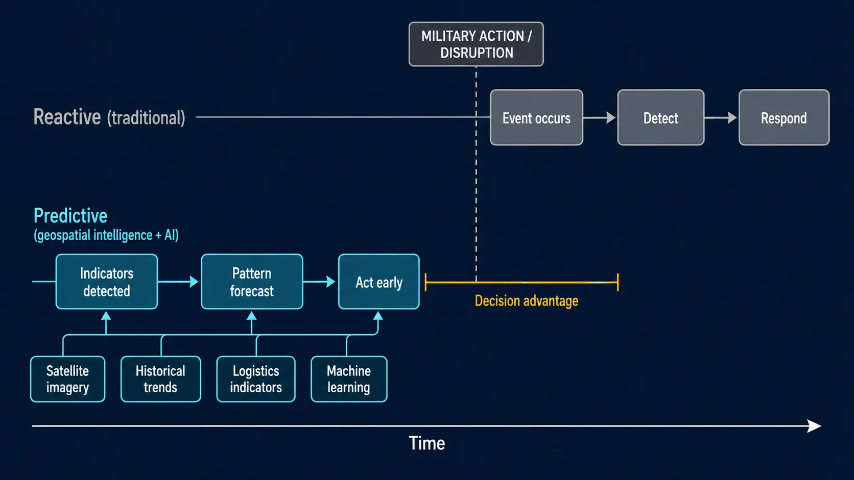
What separates prediction from monitoring is the treatment of time. Monitoring reports the present, whereas prediction reads sequences of activity over days or weeks and assigns probability to what follows. A single satellite pass is a snapshot; a pattern of passes, layered with logistics, terrain, and historical context, becomes a trajectory. It is that trajectory, rather than any individual image, that allows an organisation to act ahead of an event rather than in response to it.
Predicting military action inside the OODA loop
This evolution can be understood through John Boyd’s OODA (Observe–Orient–Decide–Act) loop. Boyd argued that success depends on moving through these four stages more effectively than an opponent. Observation gathers information, orientation interprets it in context, decision selects a course of action, and action executes it. Critically, advantage comes not simply from moving faster but from shaping an opponent’s understanding of reality, forcing them into a cycle of continual reassessment and delayed response.
Space-derived geospatial intelligence has the potential to compress the Observe and Orient phases dramatically. By combining satellite imagery with historical trends, environmental data, logistics indicators, and machine learning models, organisations can begin to forecast rather than merely monitor. For commercial operators, this means optimising operations and mitigating risk before disruption occurs. For defence organisations, it means identifying vulnerabilities, positioning forces, and employing diplomatic, informational, economic, or military levers before an adversary commits to action. Staying inside that loop does not demand perfect foresight. It requires being consistently a step ahead, narrowing the gap between observation and action until an opponent is left responding to a situation that has already moved on.
The dual-use nature of predictive space capabilities
This highlights the inherently dual-use nature of modern space capabilities. The same commercial data and analytics that enable insurers to estimate catastrophe losses, energy companies to monitor assets, or investors to assess economic activity can also provide governments with strategic warning, the discipline known in defence as indications and warning, and a clear operational advantage. Increasingly, innovation is occurring in the commercial market first, with defence adapting and integrating these capabilities rather than developing them independently.
From decision support to prediction support
The strategic premium is therefore shifting from decision support to prediction support. Whether the objective is commercial resilience or military deterrence, the organisations that can reliably anticipate events will shape markets, influence competitors, and stay inside an adversary’s OODA loop. The capability that delivers this is no longer exotic. It is being assembled now from commercial satellites, open data, and machine learning, which means the advantage will accrue to the organisations that learn to use it first rather than to those with the largest budgets. In the emerging data economy, the greatest value of space-derived geospatial intelligence is not that it tells us what has happened, it is that it helps us understand what is likely to happen next.


