There are many industries that need reliable and timely information and intelligence related to infrastructure such as buildings, powerlines, roads, railways, bridges, dams, in fact any large infrastructure. Whether it be for monitoring, maintenance, insurance or safety it is essential to have regular inspection and evaluation of infrastructure.
One key challenge is that assessing risk to infrastructure can be a costly and time-consuming activity. It typically requires people on the ground to carry out the assessment work which can create additional health and safety risks where the infrastructure is remote or inaccessible. Consequently, it can also be very expensive. In the case of linear infrastructure such as powerlines and pipelines this can involve extensive travel and difficulties in getting close to the infrastructure.
Many companies are using drones to carry out this work, but there are limitations to this approach due to factors such as the scale of the infrastructure, lack of georeferencing, as well as technical difficulties when creating accurate 3D models/point clouds. The legal requirements needed to fly drones can be challenging in controlled airspace. Local regulations may also limit their range by requiring line of sight between an operator and the drone.
Another approach to capturing imagery is to use aircraft which can overcome some of the limitations of drones, but they are expensive to operate and again have limitations, both physical and regulatory as to where they can be flown.
Satellites can operate anywhere and don’t need on the ground or active operation personnel to capture the data.
Artificial Intelligence to create 3D models
Earth-i has access to over 24 different satellites to capture imagery and video of infrastructure and then can use automated technology such as Artificial Intelligence and Machine Learning to interpret the data and to evaluate the status and risk levels associated with the infrastructure.
Satellites capture multi-angled images, or video, of the area of interest and then use advanced software to create 3D digital models of the infrastructure and surrounding area. By doing this we can calculate the height and volumes of buildings, the height of nearby objects such as trees, pylons, other buildings and so on. This allows us to assess the proximity risks posed to the infrastructure by these objects, for example, knowing the height of a tree, the distance from a powerline or building allows the assessment whether the tree poses a risk or not.
In addition to risks from nearby objects or structures we can assess fire risks from vegetation proximity, flood risks by using the digital elevation model created and even landslide and avalanche risk.
Applications of 3D Models/DEMS
The 3D models and volume information on mines, buildings and other infrastructure is used to deliver further valuable insights including predictive modelling based on historical change analysis.
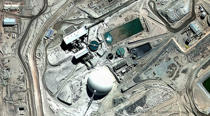
Earth-i is creating 3D models of copper mines across the world on a regular basis. Not only does this provide an excellent visual record of the geo-located mine but is also a vital data source for assessing further information about the mine. From this data source, we are able to monitor activity levels, calculate volumetric change, conduct slope analysis remotely, and even calculate the outputs of the mine over the preceding period.
In addition to using 3D, Earth-i use Machine Learning to create models for use with our Artificial Intelligence algorithms to detect roads, railway lines, buildings, pipelines, bodies of water and so on. This allows us to provide risk assessments based on factors such as ease of access by emergency services as well as provide accurate data such as the actual location of a building or other infrastructure to allow swift response to the right place. When used in conjunction with other sources of data such as the locations of fire hydrants or other sources of water such as pools, ponds, lakes etc. it is possible to automatically assess the damage risk to infrastructure related to potential response times for emergency personnel.
Earth-i delivers our world-class Digital Elevation Model service to provide another level of support for decision makers and analysts on a simple ‘pay-as-you-go’ basis. If you’d like further information on creating a DEM for your area of interest, please contact: info@earthi.space.co.uk