Colour High Definition video from space is catalysing fundamental and disruptive changes for the Geospatial Intelligence and Earth Observation industries. Earth-i claims its place as the global leader, and we are not alone in recognising the value of video from space with others in the early stages of looking to develop their own video constellations.
Earth-i’s full-colour video constellation concept is the most developed, best marketed and has the global market and technology lead. There are two prototype satellites already in orbit which has enabled substantial R&D work to be undertaken by Earth-i on the development of space video exploitation techniques and how these integrate with airborne and terrestrial video datasets.
We are focused on commercialising this space video data, extracting yet more useful information for our clients from the unique data attributes provided in part by the additional contextual information provided in a moving image. Think of how the newer iPhones capture just a fraction of a second of movement when they take a still image, and even that smallest of small snips of video adds context that really brings the image alive. Satellites in Earth-i’s ‘Vivid-i Constellation’ capture up to 2 minutes of full motion high definition colour video over a 25 km² area from multiple angles – which is great for 3D model creation – and with varying frame rates and shutter speeds. This enormous flexibility provides us with clever ways of getting more utility and flexibility from the satellites with endless permutations of image capture, video being just one by-product of this versatility.
Top 5 uses of video from space:
 Improved & Faster Object Recognition – More data from multiple angles helps to identify an object by type and enables more accurate classification (e.g. you can identify it is an aircraft, but also what type of aircraft and to some degree how it is configured). By having full colour capabilities it allows for further differentiation of objects of the same type or structure.
- More Accurate 3D Modelling – To create a standard 3D model or Digital Elevation Model (DEM), traditionally a stereo pair of still satellite images are required (two pictures focused on the same point but from different angles). When using a traditional stereo pair, it is often accepted that the resolution is often doubled to create a DEM, for example 50cm resolution satellite images create a DEM accuracy of 100cm.
However, using video and many of the 50cm resolution images from a single pass of a satellite, a DEM can be created that has an accuracy of 25cm – a four-fold increase in the accuracy of the like-for-like dataset. Colour adds further context, visualisation and interpretation when a DEM is overlaid with the original imagery.
- More Accurate Change Detection – Earth-i’s video satellites can create 3D elevation models from every pass of the satellite over a target area; they can use flexible imaging modes not available on still-imaging satellites to achieve high dynamic range (HDR) capability. Each video-enabled satellite will collect information in the 4th dimension – time – and identify movement as well as help with extracting new pattern-of-life information.
This richer data with added context enables more accurate change detection between each video data acquisition event.
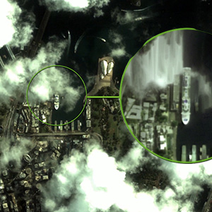 Mitigate Effects of Cloud Cover – Almost very GIS, geospatial or remote sensing specialist using optical sensors has probably been tripped up with the issue of cloud cover. By capturing a video dataset, imagery can be captured around patchy cloud ‘staring’ at the target area of interest as the satellite glimpses through gaps in the cloud as it passes overhead and changes its position over a 2 minute period in relation to each area of cloud. Then, for example, a single composite image can be re-created using the best cloud-free parts of each frame captured by the satellite.
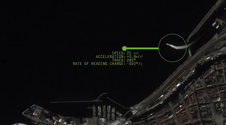
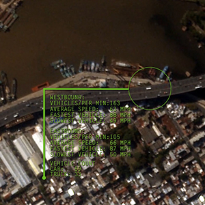
- Movement Identification and Analysis – Video can be collected at variable frame rates up to 50 frames per second (FPS). Multiple frames allow for object movement to be identified, which is not always possible in a standard, static satellite image. Object movement helps to identify if a site is active or inactive. If active, analytics can extract movement characteristics of objects such as speed and direction, deriving further information such as road quality and low risk access/egress routes.
Earth-i leverages geospatial data and complementary datasets through extensive use of Artificial Intelligence and Machine Learning technology and other analytical techniques to produce Geospatial Intelligence. Ultimately, we help our clients make better-informed decisions.
Take a look at the first video we released from VividX2, our service demonrator satellite, via our YouTube channel.
Alternatively, sign up to our newsletter to receive a brand new video from VividX2 in each issue.


